Back
 Back
Back
Pragmatic and standardized flood risk analysis
Pragmatic and standardized flood risk analysis in the scope of hazard mapping, development of a methodological handbook and a GIS analysis toolbox
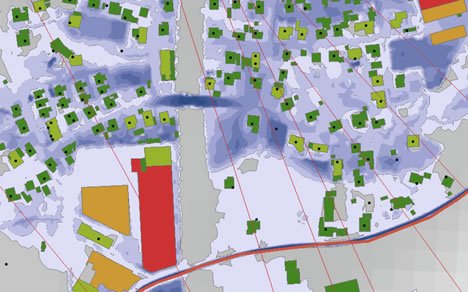
Assessing the potential flood damage in different areas of the evaluated river is highly relevant for a fair distribution of funds and resources (like river engineering). The alpS GmbH is developing a tool for the government of the state of Oberösterreich for a pragmatic and standardized analysis of flood damages. This allows for an objective comparison of different areas affected by the flooding. For that purpose, an ArcGIS Tool is developed that evaluates the exposition of and the damages to buildings, the number of affected people as well as the affected critical infrastructure.
Status:
completed
Period:
07/2018 - 03/2020
Region:
Austria
Upper Austria
Department:
Water & Climate
Contact: